
Mumbai Local Trains Map
Mumbai Local Trains Map
Mumbai Local Train Map Download – Mumbai Local Train Map Download PDF

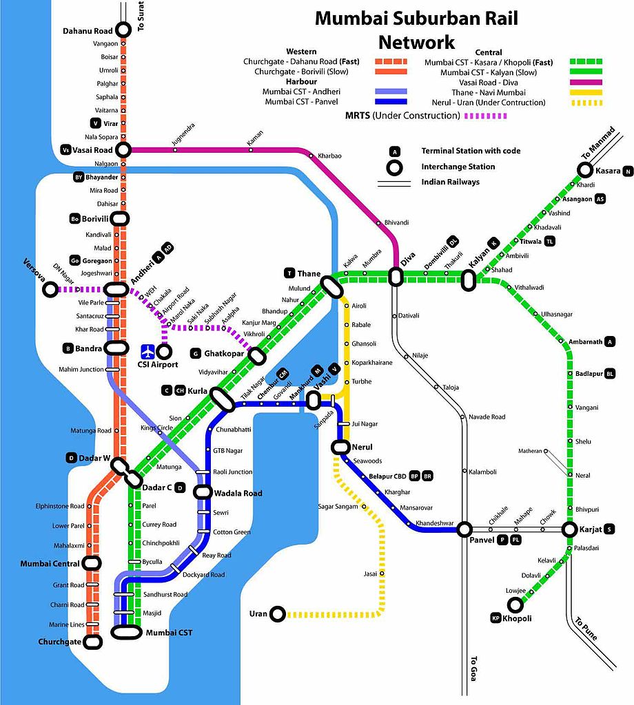
Here’s a schematic map of the Mumbai Suburban Railway network, sourced from Wikimedia Commons. It clearly highlights the three major lines—Western, Central, and Harbour—and their interconnections.
Key Features of the Mumbai Local Network
- Three main lines:
- Western Line: Connects Churchgate in South Mumbai to Dahanu Road in the north. Operated by Western Railway; known for fast and slow train services across a quadruple-track section.
- Central Line: Starts at Chhatrapati Shivaji Maharaj Terminus (CSMT) and branches out toward Kasara and Khopoli, serving key suburbs like Thane, Dombivli, and Kalyan.
- Harbour Line: Also starting from CSMT, it travels through Navi Mumbai, reaching Panvel, with extensions up to Goregaon, improving connectivity across central and eastern zones.
Network Context & Commuter Overview
- The Mumbai Suburban Railway spans approximately 450 km of suburban-standard tracks (not including MEMU routes and greenfield lines), serving over 6.2 million daily passengers. It operates around 2,342 train services every day.
Want a Printable or Integrated PDF Map?
Here are some excellent resources:
- Printable Mumbai Train Maps (A4, multilingual): Include station codes, fast/slow line details, and travel-time references.
- PDF System Map for Central Railway (Mumbai Division): Covers suburban lines and broader network layout.
- Individual line system maps and route breakdowns also available via official CRIS and railway zone portals.
Additional Insights and Updates
- Longer trains: 15-coach locals are being rolled out to improve capacity by ~33%.
- Safety upgrades: The “Kavach” anti-collision system will be introduced across all suburban EMUs.
- Infrastructure expansion under MUTP IV aims to strengthen safety, connectivity, and station access.
If you’d like, I can help you download one of these maps as a PDF, highlight specific lines, or include metro/transit overlays for comprehensive navigation. Just let me know!