

Indian Railways Schematic Network Map 2025
“A plan is the transport medium which conveys a person from the station of dreams to the destination of success. Goals are the transport fees.”
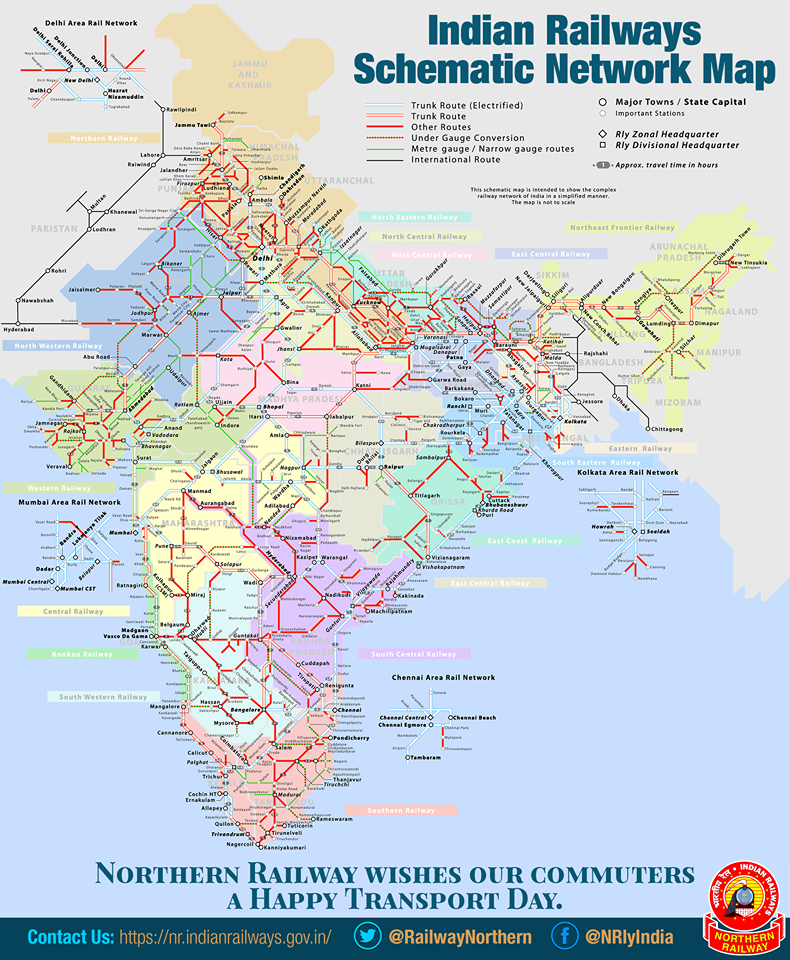

Click Here : Indian Railway Map 2025 pdf Download


Here’s the most widely available schematic map of the Indian Railways network, based on official visuals and public domain resources. While the underlying design dates back to 2006, it still reflects zones, major lines, and cities—though it’s due for an update toward a 2025‑vintage version
🧭 Indian Railways Network – 2025 Highlights
1. Network Size & Structure
- As of March 2024, the rail network includes approximately 69,734 km of broad-gauge tracks, with 98.9% electrification coverage (~68,952 km electrified)
- Broad gauge now dominates: ~96.6% of the network. Meter gauge and narrow gauge are nearly obsolete outside heritage lines
2. Zonal & Division Map
- The map indicates all 17 operational Railway Zones and their respective divisional networks, updated through mid‑2025. A proposed South Coast Railway Zone is pending operational status
3. Modernization Milestones
- Nearly 100% track electrification achieved in most states: notable exceptions include Assam (~86%) and South Western Railways (~95–96%)
- The nationwide Project Unigauge has largely concluded, phasing out non‑broad‑gauge lines except heritage routes like Kalka‑Shimla, Darjeeling, Nilgiri Mountain railways
🧱 Map Usage: What It Shows—and Doesn’t
✅ Shown:
- Major and trunk broad‑gauge corridors connecting cities and junctions.
- Zonal boundaries and key railway zones.
- Schematic overview useful for high-level systems planning.
❌ Not Shown:
- Detailed electrified vs non‑electrified sections (the schematic lacks electrification coloring).
- Dedicated Freight Corridors (Western & Eastern DFC) or high-speed lines like the Mumbai–Ahmedabad HSR.
- Under-construction or new regional lines added post‑2006.
📍 More Current & Detailed Maps
- The Ministry of Railways (Railway Board) publishes updated zonal maps and division maps on its official portal. These are periodically refreshed (last reviewed May 2025) and more granular than this schematic
- For electrification and project-specific overlays (e.g. North Eastern Railway connectivity, DFC maps), you can reference state-wise route km and project data released by COR
✅ Quick Reference Table
| Feature | This Schematic Map | Updated (2025) Trends |
|---|---|---|
| Zonal & divisional boundaries | Yes (as of 2006‑2010 era) | Still accurate, with 17 zones (SCor pending) |
| Broad‑gauge route layout | Yes | Network now nearly fully BG (>96%) |
| Electrification status | Not indicated | ~98.9% of network electrified |
| Freight corridor or HSR routes | No | Western/Eastern DFC and high-speed corridors ongoing |
| New/converted lines (post‑2006) | Not shown | Many added since: New Delhi–Meerut RRTS, HORC, etc. |
🧰 Want More Customized Views?
- For zonal/divisional maps with exact subdivisions and stations: see the Railway Board website
- For electrification maps and state-by-state completion rates, refer to COR’s May 2025 publication (listing electrified BG km by state/zone)
- For project-phase overlays, such as under-construction lines or corridors in specific states (e.g. Northeast connectivity): consult NER/NFR/NHSRCL project maps
Would you like maps focused on a specific railway zone, the double‑tracked electrified corridor, or major new project overlays in 2025? I can fetch or summarize those for you.